


Introduction
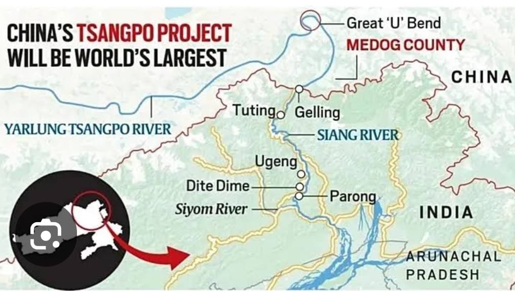
Brahmaputra River originates from the Chemayungdung Glacier in the Southern Plateau of Tibet, where it is called Yarlung Tsangpo, it flows East along the Tibetan Autonomous Region. Before entering Arunachal Pradesh in India, it makes a dramatic U turn, called the Great Bend and falls 2000 meters in height creating the worlds deepest canyon, which is three times deeper that the Great Canyon in the USA. Brahmaputra flows from Arunachal Pradesh to Assam and enters Bangladesh before flowing into the Bay of Bengal.
China, on 19 July 2025 has officially commenced the construction of a super hydropower project on Yarlung Tsangpo River at the Great Bend in Medog region of Tibet, close to Indian border at a distance of barely 50km.
The Project, also known as Motuo Hydropower Station, consists of five cascading hydropower stations and is being constructed at an astronomical investment of 1.2 trillion Yuan/ $167 billion.
This will be the biggest dam of the world and the most expensive infrastructure project of the present times. The project will be three times the capacity of the existing largest dam of the world, called China’s Three Gorges Dam on Yangtze River.
The Dam will generate 300 billion KWh of electricity annually, which will be sufficient to cater to the power needs of 300 million people.
Reasons Why China is Building this Dam
- China has committed itself to achieve carbon neutrality by 2060. Hence, the Project aims at delivering clean and renewable energy primarily for external consumption in China, while also addressing local demand of Tibet.
- Tibet has been aspiring to gain independence from China and has been held together forcefully by China since the late 1950s. This massive investment will create jobs, improve economy and appease the local Tibetans. The same may help China to improve stability in the region.
- Besides, power generation, the Project also provides China with a leverage to control trans boundary water resource and use it as a strategic tool of negotiation with downstream neighbour’s, i.e. India and Bangladesh. In an event of conflict like it happened in Doklam in 2017 and Galwan in 2020, China could use water as a tool of coercion for settling the negotiations in China’s favour.
Implications for India
- China and India do not have any formalized water sharing agreements or an institutionalized mechanism for resolving trans boundary water disputes.
- China could use this mega Dam as a ‘water bomb’ in case of a conflict with China by releasing unprecedented amount of water and cause flooding. The same may result in major damage to lives and infrastructure, especially in the Siang region of Arunachal Pradesh.
- Besides, uncertainty regarding the amount of water released from the upstream Dam, could disrupt the traditional farming cycles of people living in Arunachal Pradesh and Assam, who largely depend upon river water for farming. Hence, adversely affecting the livelihood of millions of citizens of India, especially of Adi tribe living in Siang region of Arunachal Pradesh.
- Assam, almost every year faces massive flooding during monsoons and an increased flow of water during the monsoons could make the flooding more destructive.
- China has been claiming Arunachal Pradesh as its own territory, calling it South Tibet. We must understand that regional development is very closely connected with national security concerns. Water scarcity could lead to cross border migration in this very sensitive region in search of livelihood and sustenance.
Implications for the Region
- The proposed Dam Project sits over highly active tectonic plates and a future earthquake could pose a very serious threat of flooding and inundation in the region.
- Restricted flow of water could lead to water scarcity for agriculture, as well as drinking water in the Indian states of Arunachal Pradesh and Assam and also in Bangladesh.
- Construction of such a mega project will lead to massive displacement of local population in Tibet.
- The risk of altering the natural course of the river will affect aquatic life and biodiversity in Tibet, which is considered as a treasure trove of biodiversity, as also in India and Bangladesh, especially the Sunderbans.
- Salinity of water near the Bay of Bengal will increase due to reduced flow of water.
India’s Options to Respond
- India could expedite the construction of Upper Siang hydropower Dam, which is being built on Brahmaputra in Arunachal Pradesh. This Dam could serve as a buffer in case China suddenly releases water to flood the region.
- Intensify efforts to establish formal water sharing mechanisms with China.
- Take steps to involve Bangladesh, the other lower riparian state, to create opportunities for negotiations and consensus with China.
- Use technologies, like satellite monitoring, AI and data analytics for tracking water flows and predict environmental impacts.
Conclusion
China has informed India that the construction of this Dam will have no adverse affects in India. However, China has always been unreliable. China has similarly constructed Dams on Mekong River that passes through six countries, besides China, it passes through Myanmar, Thailand, Laos, Cambodia and Vietnam and soaked up 70% of Mekong River water unilaterally. Hence, whether China uses Motou Dam as weapon or not, only time will tell.